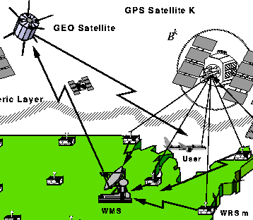
A variant of GIM technology is being implemented for the Federal Aviation Administration's Wide Area Augmentation System (WAAS), as part of a new aircraft navigation system based on GPS. Due to begin Phase-I operation in 1998, this robust, real-time system will provide ionospheric vertical delay calibrations accurate to 50 cm or better to all WAAS users in the US (uncalibrated delays can reach 14 meters during solar maximum).
JPL's WAAS Ionospheric Software (WIS) will be used to estimate the delays over a set of Earth-fixed grid points that are spread out over the coverage area. The delay at each grid location will be broadcast to users who will then estimate the delay at their position, which is generally off the grid. The corrections are based on dual-frequency GPS data collected from a network of 24 GPS reference receivers in the US, being implemented as part of the WAAS program.


